
Rivers and streams cover more of the Earth than previously thought and therefore play a greater role in controlling concentrations of greenhouse gases in the atmosphere, according to a new study.
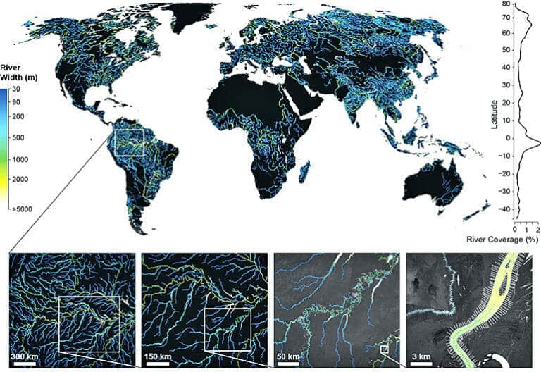
Using satellite images from NASA, the team developed the Global River Widths from Landsat (GRWL) Database, the most comprehensive global map of river length and width.
“We were able to measure over two million kilometers of rivers that were wider than 30 meters,” says George Allen, an assistant professor of geography in the College of Geosciences at Texas A&M University.
For the rivers that were too narrow to accurately measure from the satellite images, the researchers applied a novel statistical technique that utilized the fractal characteristics of river networks. “There are many more narrow rivers than wide rivers, and we found that the relationship between river length and width is actually pretty predictable,” Allen says.
“We added up all the rivers and streams around the world [and] got an area larger than the size of Texas. The estimate was significantly larger than the previous best estimate, particularly […]
Full article: Rivers cover a lot more of Earth than we thought
More about rivers and watersheds:
Why river floodplains are key to preserving nature and biodiversity in western USA
WWF Report Explores Rivers’ Less Valued Benefits
How planting trees and grasses can help stabilise farmland in a changing climate
The veins of America: Stunning map shows every river basin in the USA
River Revives After Largest Dam Removal in USA History
Cleansing the Air at the Expense of Waterways
3 Surprising Ways Water Depends on Healthy Forests
