
Full article: The veins of America: Stunning map shows every river basin in the US
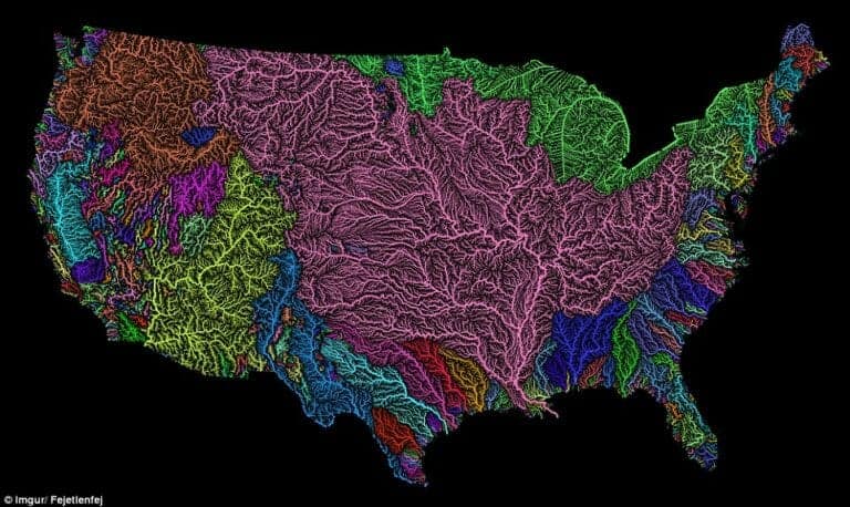
A stunning new map shows the complex network of rivers and streams in the contiguous United States. Created by Imgur user Fejetlenfej, a geographer and GIS analyst with a ‘lifelong passion for beautiful maps,’ it highlights the massive expanse of river basins across the country – in particular, those which feed the Mississippi River. The map visualizes Strahler Stream Order Classification, the creator explains, with higher stream orders indicated as thicker lines.
[A related video was created] by Imgur user Fejetlenfej, a geographer and GIS analyst with a ‘lifelong passion for beautiful maps,’ it highlights the massive expanse of river basins across the country – in particular, those which feed the Mississippi River, in pink. It was created using the open-source QGIS software, and the high-resolution prints are available on Etsy. There are 18 major river basins in the 48 states of the contiguous US, but much of the map is dominated by the massive catchment area for the Mississippi River, including the Upper and Lower Mississippi River Basins, along with Missouri River Basin and the Arkansas-White-Red Basin, as seen in pink.
The top left portion of the map shows much of the Pacific Northwest […]
More about rivers and watersheds:
Five gross things we used to dump in the Mississippi River — and what we’re dumping now
How planting trees and grasses can help stabilise farmland in a changing climate
Rivers cover lots more of the Earth than we thought
River Revives After Largest Dam Removal in USA History