Credit: Bryan Riel and Mark Simons
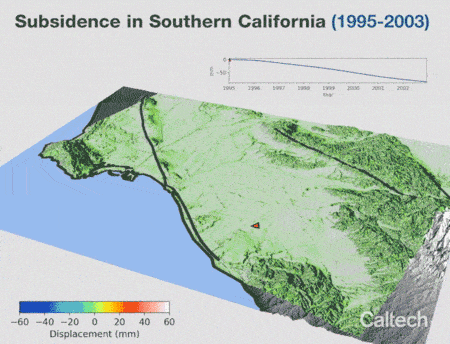
Using an unprecedented number of satellite radar images, geophysicists at Caltech have tracked how the ground in Southern California rises and falls as groundwater is pumped in and out of aquifers beneath the surface.
Their findings are presented in a study that tracks deformation of the earth’s surface over an 18-year period. The work can be used by water management districts to assess the precise shape and size of aquifers and the impact of the region’s water use on those aquifers.
The work also reveals what could be a previously unmapped fault running across northeast Orange County.
"What we see through the rising and falling of the ground surface is the elastic response of the land to regular changes in groundwater level," says lead author Bryan Riel (MS ’14, PhD ’17), who was a graduate student in the lab of Caltech’s Mark Simons at the time of the research, and is now a signal analysis engineer at JPL, which is managed by Caltech for NASA.
"Because we have data over a long period of time, we were also able to isolate long-term surface deformation signals, including subsidence of the land that seems to […]
Full article: Animation Based on Satellite Data Shows SoCal “Breathing” Water
More about ground subsidence and water usage:
Sinking land, poisoned water: the dark side of California’s mega farms
The Valley floor is sinking, and it’s crippling California’s ability to deliver water
Exploring the Hydrodynamics of Sediment Diversion at Mid-Barataria
Mississippi River Sediment Diversions & Louisiana