
See link below to full original article by WWALS Watershed Coalition (Suwannee RIVERKEEPER®)
See link below to full original article by WWALS Watershed Coalition (Suwannee RIVERKEEPER®)
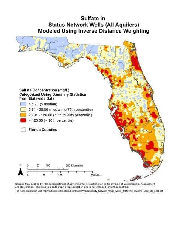
Update 2017-05-18: Salt water intrusion inland is worse than you think, including the “Apalachicola salinity feature” up to the GA-FL line and east through Lowndes County, with a special additional brackish Valdosta feature. See Revised Hydrogeologic Framework of the Floridan Aquifer System 2016-03.
Salt water and other solids are coming up in Florida wells far inland from the sea, right up to the state line, and it probably doesn’t stop there. The problem is worse on the coasts and in south Florida, but north central Florida is not immune, judging by these preliminary maps by the Florida Department of Environmental Protection. Likely culprits would seem to include overpumping.
WWALS requested permission to post these maps 10 July 2015, and it was granted 3 September 2015 by Rick Copeland, P.G. Ph.D., Environmental Consultant, Florida Department of Environmental Protection (FL-DEP), to use MAPS-Read_Me_First.pdf as the official summary. The text of that file is quoted below; all other remarks are not by FL-DEP. The example maps in this post are for statewide preliminary results; other blog posts will include more specific maps. Salinity Network Workgroup Preliminary Maps for Developing a Coastal Salinity Monitoring Network.
Background: Over the past several decades, Florida […]
Full article: Florida Well Salinity Study
More about salinity:
Scientists warn of salt pollution of freshwaters — salinity
How climate change could threaten the water supply for millions of Californians
Seagrass Die-off and How Freshwater from the Everglades gets into Florida Bay