
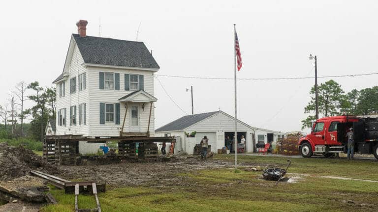
Mike Draper raised his house in southern Dorchester County seven feet to protect it from rising waters. PHOTO BY DAVE HARP
Maryland’s Dorchester County is ground zero for climate change on Chesapeake Bay, as rising seas claim more and more land. An e360 video explores the quiet beauty of this liquid landscape and how high tides and erosion are putting the bay’s rural communities at risk.
I’m making a film in the Chesapeake Bay landscapes of my boyhood, posing for a close-up with ball and glove where 60 years ago I shagged flies out front of my Dad’s fishing cabin. The camera backs away and I’m ass-deep in salt water — centerfield, this used to be. The tall piney woods around the long-gone cabin, thick enough I worried then about getting lost, are skeletal now, falling into the water.
Cinematographer Dave Harp and I are longtime collaborators on Chesapeake projects and knew what we’d find when we began working on this film. The great estuary’s 11,000 miles of tidal shoreline have been eroding for centuries as wind and wave and ice take their toll. But now there’s a new ballgame. Emerging climate science has documented an ominous acceleration of the sea level rise that gradually formed the Chesapeake over thousands of years. The latest projections for the Chesapeake region are two feet or more of sea level rise by mid-century, and as much as six feet by century’s end. That’s a troubling combination of higher water and sinking land around the bay.
Dave and I have focused our cameras on my old stomping grounds, Dorchester County on Maryland’s Eastern Shore, a place where the future is well underway. “Water moves us” is the county’s tourism slogan, both apt and ironic. It’s been called “Maryland’s Everglades” — a wonderland of water and wetlands, tidal creeks and wooded swamps and islands, nurturing an abundance of seafood and wildlife, and home to historic fishing communities and the internationally-known Blackwater National Wildlife Refuge. With its hundreds of thousands of acres of land, Dorchester ranks fourth largest among Maryland’s 23 counties; but it will shrink to 14th by 2100 as nearly half the county turns to open water.
To most people, the word “tide” has only vague import — high and low, flooding and ebbing. But “tide” in Dorchester is rich with meaning: school bus schedules and shopping trips revolve around it; emergency responders reposition ambulances; and property owners truck in soil on which to park their cars, grow vegetable gardens, and install septic tanks.
In the southern portions of the county you can easier come by a bushel of crabs than a wheelbarrow load of […]
Full article with video: On the Chesapeake, A Precarious Future of Rising Seas and High Tides
More about the Chesapeake Bay:
Bringing the Chesapeake Bay to Baltimore’s Inner Harbor
Study: Edible Crabs Won’t Cope With Effects of Climate Change on Seawater
Scientists uncover a centuries-old case of mistaken identity in the Chesapeake Bay
