
A new model deploys a neural network to spot beavers’ engineering exploits in aerial and satellite imagery, an approach that should aid studies of ecosystem and landscape change.
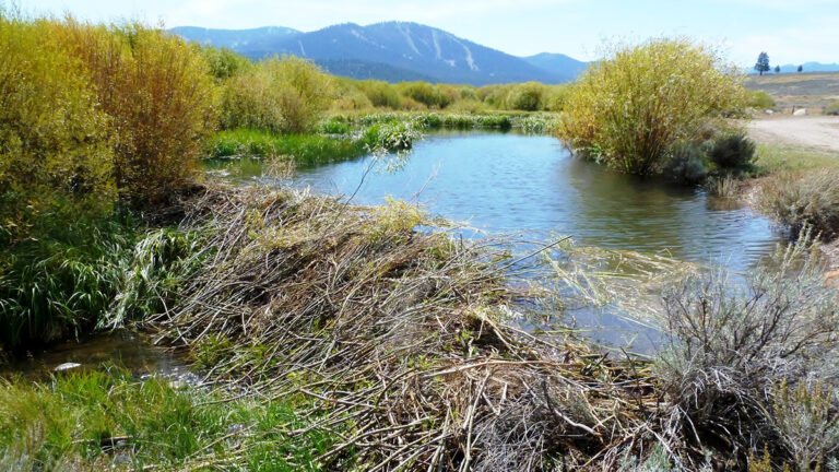
Photo: Beaver dams like this one on Martis Creek near Lake Tahoe in California are important features in wetland areas. Mapping where beaver dams are and studying the surrounding ecosystems over time help scientists understand changes in landscapes and beaver populations. Credit: Schmiebel/Wikimedia Commons, CC BY-SA 3.0
Source: Journal of Geophysical Research: Biogeosciences
North American beavers transform ecosystems with their engineering prowess. By ponding water, excavating channels, and foraging nearby vegetation, they drastically alter landscapes across a variety of environments, from tundra to deserts.
Two centuries of fur trading starting in the 17th century decimated the thick-coated builders, but today, beaver populations are rebounding gradually. That’s good news for many ecosystems because beaver construction creates valuable habitats for endangered species, traps carbon, and improves water availability in dry places.
Despite these ecologic implications, large-scale mapping of beaver habitats has been missing from scientific research. Most mapped dams are identified manually, which takes a lot of time and effort.
To accelerate beaver dam identification, Fairfax et al. applied machine learning to scour high-resolution geospatial imagery for likely dam complexes across landscape- and regional-scale areas. The researchers developed the Earth Engine Automated Geospatial Element(s) Recognition (EEAGER) model, which uses a neural network trained on thousands of known locations of beaver dams in aerial and satellite images.
In this study, the team trained the model to identify dams in the western United States, then tested it outside the training areas to see whether it correctly spotted other dams in imagery. Overall, EEAGER was 98.5% accurate in characterizing whether sites in imaged landscapes did or did not have dams. Both the model’s recall (the percentage of known dams correctly identified by the model) and precision (the percentage of model-predicted dams that were, indeed, dams), at 63% and 26%, respectively, could be improved with additional training in different regions where beavers build, the authors note. Still, the relatively high recall is a good sign, they say, suggesting […]
Full article: eos.org