
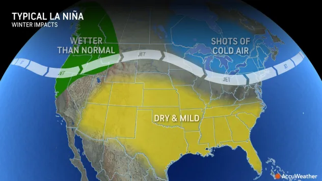
Map: Typical La Nina winter weather impacts include wet weather in the Northwest, shots of cold air in New England, and predominantly dry and mild in the South.
El Nino is showing signs of fading, and AccuWeather long-range forecasters say a dramatic return to La Nina is possible before the peak of the 2024 Atlantic hurricane season.
El Niño has been shaping the weather across North America all winter, but the tides are changing, and a major shift is on the horizon.
On Thursday, NOAA issued a La Niña watch, explaining that it could replace El Niño before the end of summer. This could have implications for the impending Atlantic hurricane season and beyond.
Back in December, AccuWeather’s team of long-range forecasters began to see signs that La Niña may return during the second half of 2024.
“The AccuWeather Long-Range team is forecasting a quick weakening of El Niño this spring,” AccuWeather Long-Range Expert Paul Pastelok said. “Through our research and climatology, La Niña could develop late summer or early fall 2024.”
What is El Niño and La Niña?
The two phenomena are linked to the area of the Pacific Ocean south of Hawaii near the equator. When the water in this region of the ocean is at least 0.9 of a degree Fahrenheit above the historical average for at least three […]
Full article: www.accuweather.com