
The California Department of Water Resources (DWR) has mapped out the state over the last few years to gain a better understanding of its groundwater basins.
The department has been using new technology combined with helicopters to create a database about what lies below.
Out of sight, out of mind, many people might not think about the water that could lie below our feet, but the DWR knows groundwater is critical to California. The state has 515 basins that can hold up to five times more groundwater than all surface water combined.
However, state officials need to learn more about these basins. With phase one of their airborne electromagnetic survey project done, they’re one step closer.
“There’s water down there but what’s it doing?” said Ken Mitchell, owner of Mitchell Farms.
The DWR is tapping into all the untapped potential stored underground. Data from the first phase of the airborne electromagnetic survey project is ready to be shared.
There’s water down there but what’s it doing?
—Ken Mitchell
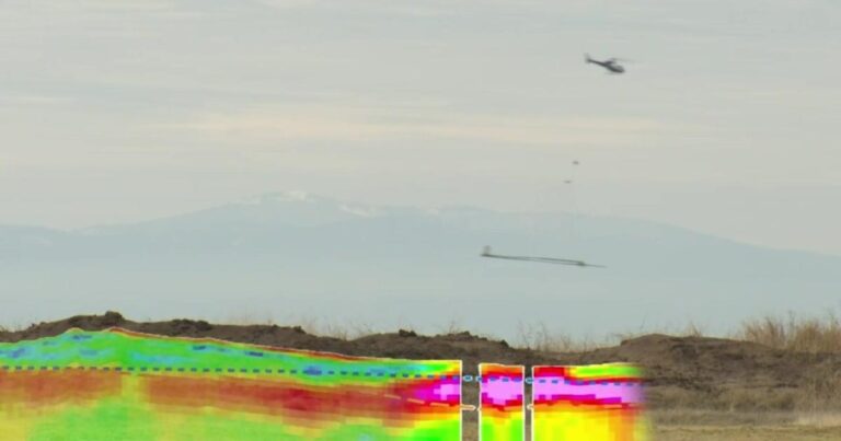
“The helicopter is towing a large hoop that sends signals into the ground that bounce off different materials, sand, silt and gravels below the ground,” said the DWR’s Steven Springhorn.
The signals penetrate 1,000 feet below the ground. It’s like an MRI for the earth, and from December 2021 to November 2023, they’ve been able to map 16,000 line miles of data across 100 groundwater basins.
Mitchell said that having a mapping system of real-time data is a game-changer.
“We’ve got a water-moving problem, a storage problem,” he said. “We haven’t built anything storage-wise in California since the mid-60s.”
Springhorn said the project was structured to benefit and help […]
Full article: www.cbsnews.com