Homes in the Spinnaker Point neighborhood stand alongside wetlands in San Rafael, Calif., on Tuesday, March 19, 2024. Nearly all of the residents in the Canal area live in the flooding zone, according to the county. (Alan Dep/Marin Independent Journal)
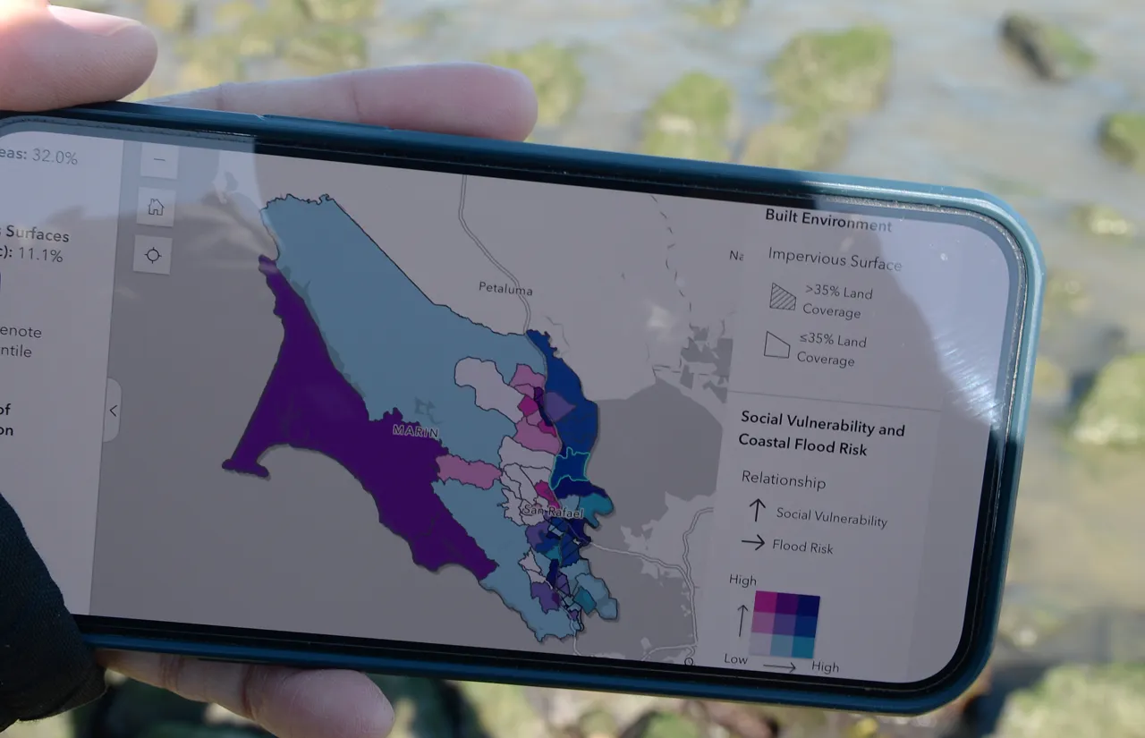
A new online tool created by Marin County’s public health office aims to chart the risks various areas face from the rising sea level.
The “vulnerability” dashboard uses social factors as well as geographic ones as the basis for its determinations. The map identifies areas in Novato, Marin City, San Rafael, Mill Valley, Kentfield and Larkspur as most socially vulnerable and with the highest flood risk.
The dashboard is meant to be a community planning tool, said Dr. Matthew Willis, the county’s public health officer. He said that historically, flood risk has been measured by physical factors such as infrastructure, elevation and water flow.
…from a human health standpoint, any disaster … the people who tend to suffer the worst consequences are people who have social vulnerability.
Dr. Matthew Willis
Factors that make a community vulnerable include the rates of medical conditions and social isolation, especially for seniors. Additionally, deteriorating housing and infrastructure can make evacuation harder or might not survive climate-related events.
“I think our tool, our goal, was to contribute to that conversation and to add important context to more dimensions around vulnerability,” Willis said. “But from a human health standpoint, any disaster, whether it’s a heat wave or a flood, the people who tend to suffer the worst consequences are people who have social vulnerability.”
Lastly, social barriers — financial, cultural, lingual — can increase vulnerability by limiting access to transportation, information, health care, social services, and food.
“…we can dedicate resources and plan interventions and strategies on those specific areas that are described as having high vulnerability demographic-wise and also high-flood-risk-wise”
Jocelyn Chung
Jocelyn Chung built the tool over about five months. Chung is in the California Epidemiologic Investigation Service Fellowship Program, which trains public health officials.
The dashboard is based on data from the U.S. Census Bureau and the California Department of Public Health.
“So we are able to identify those areas and, ideally, we can dedicate resources and plan interventions and strategies on those specific areas that are described as having high vulnerability demographic-wise and also high-flood-risk-wise,” Chung said.
Chung said the health effects of flooding go beyond injuries and displacement. Flooding can foster household mold, which causes respiratory health problems, and contaminate groundwater. Additionally, standing water increases the risk of infectious diseases.
Willis said displacement, homelessness and infrastructure disruption are huge concerns for public health officials. He said most of the deaths from […]
Full article: www.marinij.com
Coral reefs already face a litany of threats. Experts say storm runoff from the recent…
https://www.youtube.com/watch?v=0Xqa0B9r7Y8 Iowa water: Pulitzer Prize winner Art Cullen and award-winning cinematographer Jerry Risius have teamed…
Clean water is essential for life, yet millions of Americans unknowingly consume contaminants through their…
Human brains contain higher concentrations of microplastics than other organs, according to a new study, and the…
From the Office of the Governor: In anticipation of a multi-day, significant atmospheric river in Northern California,…
From Governor Newsom: Scientists, water managers, state leaders, and experts throughout the state are calling…